
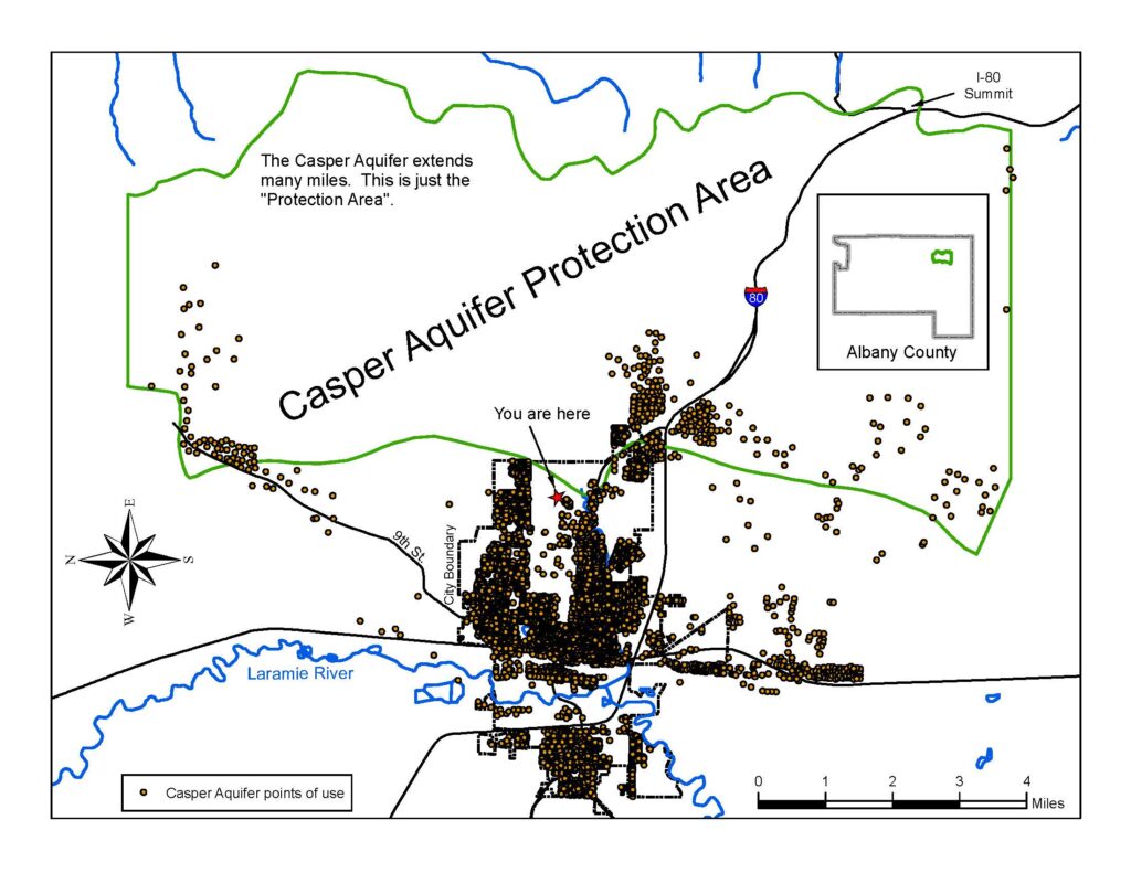
Jacoby Ridge Trail
Enjoy the four stops shown on this map along the 2 mile Jacoby Ridge Trail (off the east end of Willett Drive) to learn more about the geology of this area and the Casper Aquifer, Laramie’s main source of drinking water.
Click here for a printable version

WHERE DOES OUR WATER COME FROM?
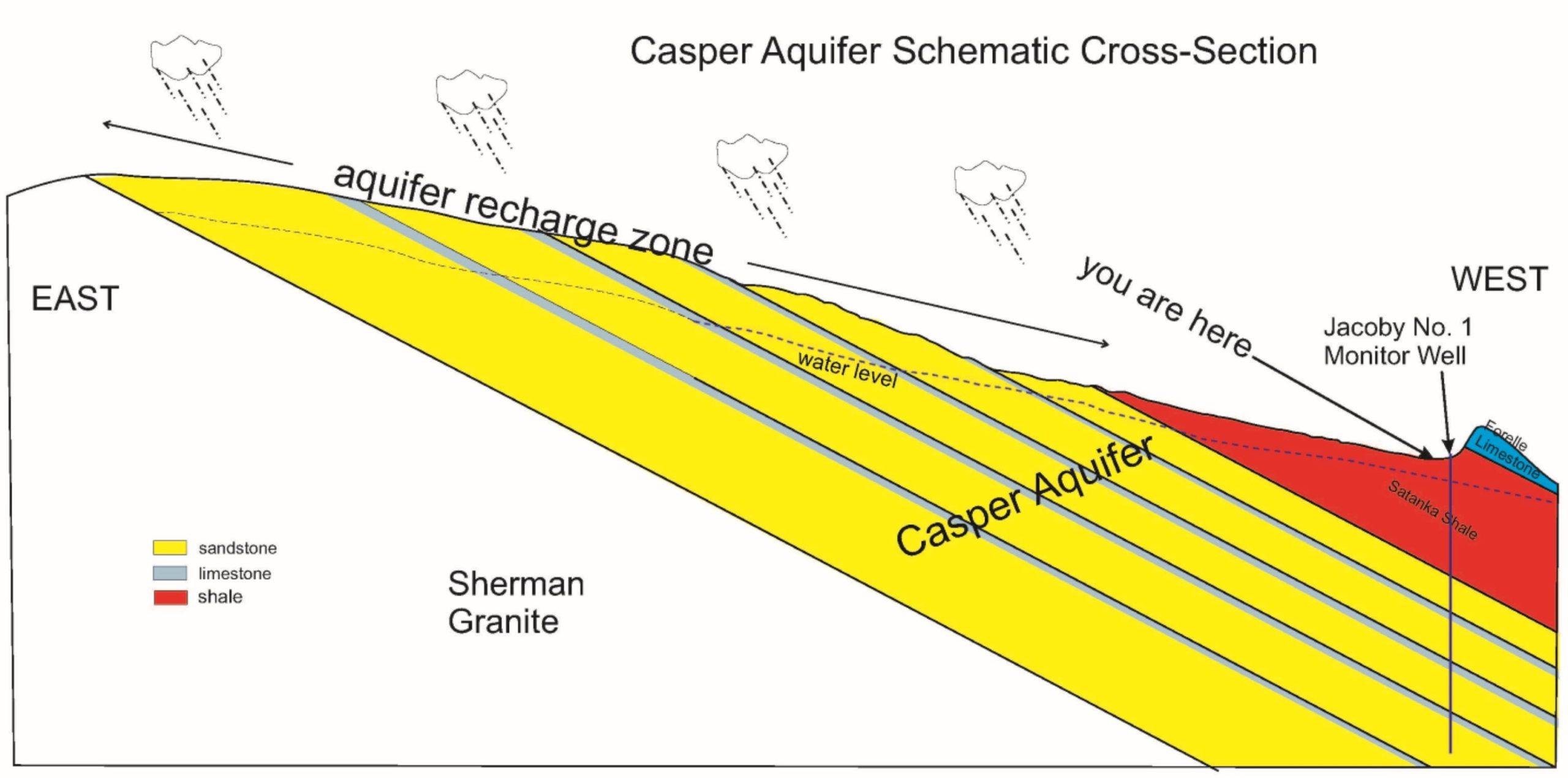
Half of the Laramie water supply comes from the Casper Aquifer (more in dry years when water from the Laramie River is not available). The Casper Formation is a stack of geologic layers that form the mountain slopes you see looking east. Rainfall and snowmelt soak into the aquifer across these slopes to recharge the aquifer (groundwater). That water is contained beneath overlying layers, but comes back to the surface via natural springs and wells. Casper Aquifer Protection Plans work to limit development in the recharge area, to keep our groundwater as pure as possible.
HOW DOES OUR WATER GET TO US?
The City of Laramie pumps water from wells drilled into the Casper Aquifer to supply the municipal system, including the South of Laramie Water & Sewer District. There also are many individual wells on residential properties east of town.
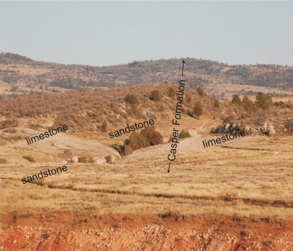
Stop A
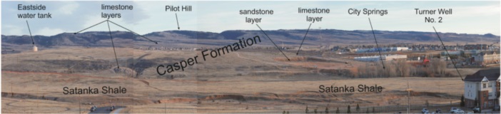
You are standing on a ridge made of limestone – the 270 million year old Forelle Limestone. On the hillside in the distance are the limestone and sandstone layers of the 700-feet thick Casper Formation. 300 million years ago, these layers were beach sands, sand dunes, and coral reefs accumulating in a sub-tropical sea.
Stop B
SATANKA SHALE
The white cobbles at the surface here are pieces of limestone from the Casper Formation. The Casper Formation is 200 feet below the surface here, but you can see it at the surface uphill (east). The rocks have washed down by erosion. A similar rocky layer is present through most of Laramie.
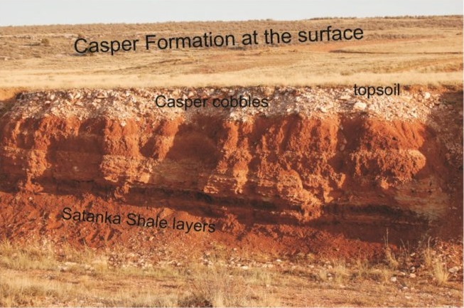
The red Satanka Shale is exposed in this stream cut. It is the source for the red soils of the valley around and behind you. This way was a mudflat 280 million years ago. Sediment eroded from far away hills baked in the sun, layer after layer of mud stacking up 300 feet thick over millions of years.
The Satanka is composed of shale here, a rock made up mostly of clay. Shale layers do not allow groundwater to move readily. The Satanka Shale provides a protective cap above the Casper Aquifer, limiting the infiltration of contaminants from the surface.
Stop C
The well in front of you is the Jacoby No. 1 Monitor Well. At this well, the top of the Casper Formation is 252 feet below the surface. The well is 756 feet deep. It is about 55 feet down to the water level, but the water level goes up and down some seasonally and in response to long-term recharge cycles.
It is about 1000 feet clear down to the 1,200 million year old Sherman Granite. That rock makes up the core of the Laramie Range, including the cliffs and boulders of Vedauwoo. Because the rock layers here dip to the west, older rocks come to the surface as you go east.
Stop D
CASPER FORMATION
On the hillside in front of this sign the limestone and sandstone layers of the Casper Formation are exposed at the surface. The hard grey rock is one of the limestone layers. Above and below it are layers of soft sandstone. Each layer slants upward to the east, do deeper layers come to the surface on up the hillside to the horizon.
The sandstones of the Casper Formation are porous and permeable, so rain and snowmelt soak in easily. Where the limestones are fractured, they also readily accept aquifer recharge. Where they are not fractured, water cannot penetrate and runs off in search of an alternative pathway into the aquifer.
Feel free to walk over for a closer look. You are on public land for the next mile east of this point.